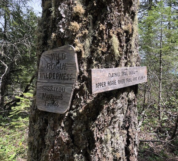
We resisted the urge to hit the trail longer than I expected to or thought I could, but my wife Amanda and I had to head to the woods. But, how the heck do you plan a backpacking trip during a pandemic? Our criteria for this trip was a 3-4 day trek, moderate difficulty, and minimal other hikers. Most outlets for info on trail conditions were lacking. Being an early season trip, with higher elevations snowed in, we chose the obvious path and headed to Southern Oregon. Memorial Day weekend is always a high probability of crowded trails, so we chose the Wild Rogue Wilderness Loop. Big props to the Siskiyou Mountain Club for reclaiming this trail and maintaining it, among many others in Southern Oregon and Northern California.
They also gave me a ton of information for our original down south destination, the Kalmiopsis Wilderness. Forced to cut off the first couple days of our itinerary, we detoured from the fifty mile Lilla and John Leach loop we originally planned. I’ll save that for spring 2021, when it’s namesake flowers are in bloom again.
The First Day on the Trail
We arrived at the Mule Creek South Trailhead about 2:30. A customary for late start for us. I absolutely had to stop at Heaven On Earth for their famous and ginormous cinnamon roll, and a shorter delay to buy TECNU for the inevitable poison oak. Parking is at the far end of Tucker Creek Campground. If it’s full, there are spots back out at the Y junction with Mule Creek-Marial Road. Despite the late start we had loaded our backpacks the night before, so we hit the trail quickly. The hike up Mule Creek Trail #1159 began auspiciously enough, with an easy grade to a bridge over Mule Creek. .
There are several reasons to start this loop here and head counterclockwise. First, we hadn’t been able to get info on the two creeks that must be crossed in the first couple of miles. They can be dangerous early in the season and we wanted the option to turn around if needed. A major tenet of mine is to always have a backup plan, you never know what obstacles may waylay your trip. Ours was to do an out and back along the Rogue River if either creek were impassible. Fortunately both creeks were easy to cross, only getting our boots slightly wet hopping across the stones laid across them.
These would’ve supplied power to old mining operations in the area.There is a plethora of old mining equipment scattered along the route.
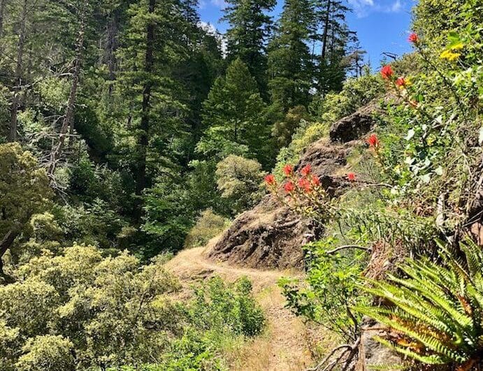
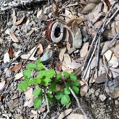
From the get go the trail is lined with poison oak. The decision to wear long pants and shirts is never easy on a hot hike, but no one wants a weeping itchy sore or ticks! For the most part the poison oak was easy to maneuver around, but it was a constant game of ducking and stepping left, then right, and back. This, while being on high alert for rattlesnakes. The Northern Pacific Rattlesnake is common here and camouflages surreptitiously with the leaf obscured path. I had hoped to spy one safely off the trail, but alas none were to be seen today. Fortunately most of the Poison Oak recedes above 2000 feet in elevation taking one worry off our minds… for now.
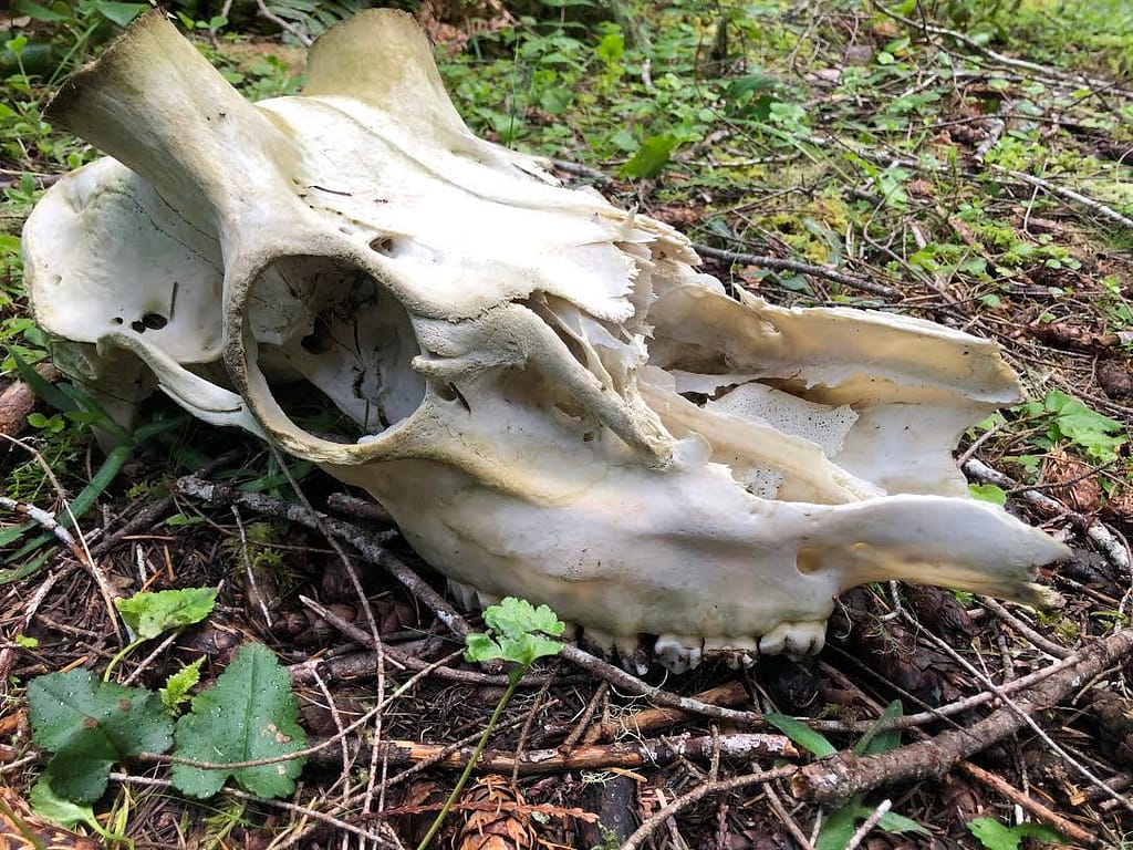
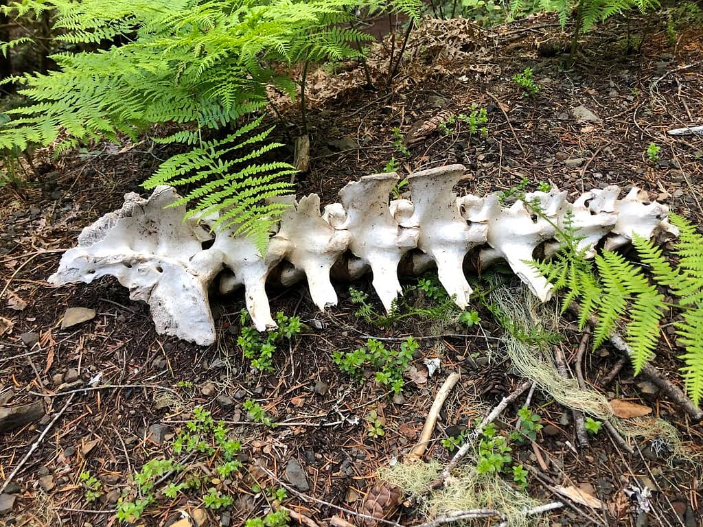
At mile 5 and change is West Fork Mule Creek, a wonderfully shaded and cool area. It was an ideal rest stop on the hot afternoon. Three sublime camp spots lie next to the creek. On busy days, the old two-track that has been our trail for the past three miles, becomes space for tents as well. Just past the camp spots was a massive weathered elk skeleton strewn along the trail. The remains gave the area an eerie feel, especially at dusk. The following evening we chatted with a brother and sister on their annual trip. They had seen a large, healthy looking black bear just a quarter mile shy of the skeleton. While I love seeing all wildlife, it helped validate our decision to move on.

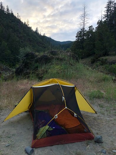
The rolly path past the camps was a nice respite from the climb up. We took another short break on a log at the Buck Point Trailhead, at the end of Forest Road 230. With no beta on the seasonal stream at our destination, we deliberated strolling to a creek a half mile down the road. Exhausted due to a lack off spring hiking and exercise because of the pandemic, I made an educated guess that the stream would be flowing. We slugged up the Panther Ridge Trail #1253, which rose another thousand feet in just a mile. A hell of a steep stretch to end the day. Approaching camp, I heard the seasonal water supply and was as elated as a tired hiker could be.
The Second Day
If you’ve read my ABOUT section, you may remember I mention making mistakes. Well, due to my being damn tired, I left my trekking poles at Buck Point Trailhead where we pitstopped. And to make a long story short, they were not there in the morning. Fortunately, we had planned to spend two nights at Panther Creek Camp, so the day hike back did not affect our itinerary.
We spent the bulk of the remaining daylight admiring the massive firs in camp and resting our sore legs. I also discovered an old trail sign near camp that may indicate a lost trail up to the area. In the evening, the aforementioned brother and sister arrived. We made sure to graciously invite them to use the other half of the camp area. While I always enjoy the solitude of a lonely camp, they were an interesting duo to chat with. Also, as it turns out they are cousins of the iconic Oregonian William L. Sullivan, who you may know from his highly respected guide books.
The Third Day

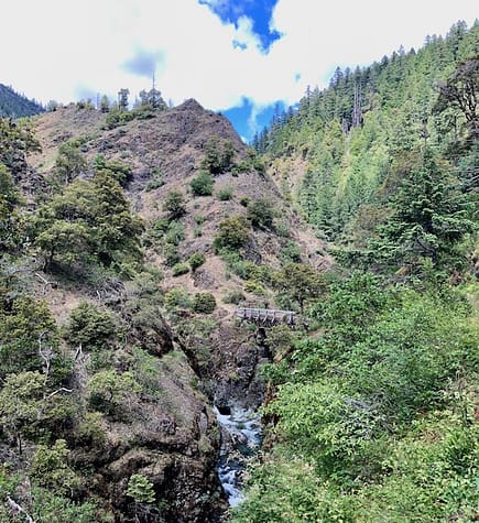
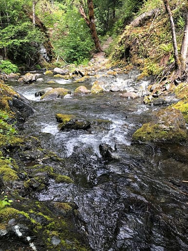
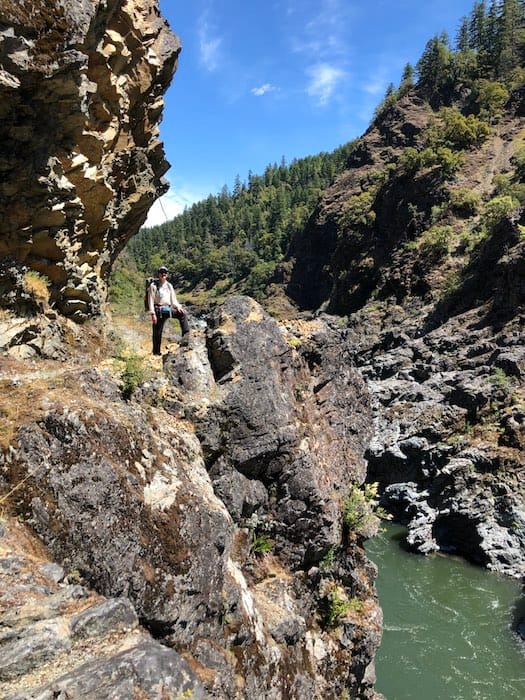
Feeling much fresher than yesterday morning, I was ready to hit the trail for our longest day. Our minimum mileage would be eleven miles and likely longer, with no access to water for at least nine of those miles. We filled our reservoirs and chugged plenty of the cool, refreshing water from the blessing of a creek. We packed up and headed up the short, but steep climb to the junction for Hanging Rock Trail #1113 . Hanging Rock is a seriously stunning outcrop above a vertical cliff that looks over the valley below. On a side note, many reports I read mentioned poor signage on the loop, but I found the markers to be accurate and plentiful.
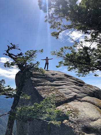
Amanda scrambled up to Hanging Rock’s peak, while I stayed below. Par for the course. If I have a hiking achilles heel, it is heights. But that’s what happens when you get stuck on top of a giant ferris wheel for an hour at age 4. I can do it when necessary, but if it’s not critical to the trek, then I’ll stay below and let her pose for the hero photos.
We had the beauty of Hanging Rock to ourselves for a good fifteen minutes before a group of twenty day-hiking yahoos showed up hootin’ and hollerin’, with a dozen dogs in tow. I use the term hiking loosely, as it’s about two-thirds mile round trip from where they started. Careful to keep our six foot plus buffer, we waited for them to parade down the trail before we headed on our way.
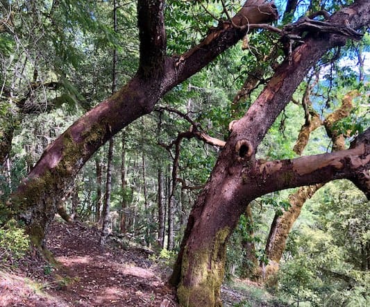
Panther Ridge rolls through a lush forest for six miles and a little bit of change. Along the ridge, views of the Rogue River Gorge are limited. With the long day and anticipation of the steep drop down the Clay Creek Trail, we limited our stops and kept a steady pace. At the tail end of the ridge the ecosystem changes dramatically from fir and green shrubbery to the rusts of madrones and a canopy of leafy oaks.
The beastly Clay Hill Trail #1160A is the other main reason to do the loop counterclockwise. It’s steep! We trudged down the path covered in oak leaves creating an ethereal tan blanket, rustling with the swoosh of our boots.
At mile seventeen of the loop is the ol’ Thomas Homestead, its green fields of grass are an alluring sight. The access trail is an obvious, unsigned right. The first of the farms two water sources is here. The barely moving stream was murky and unappealing. Also unappealing was the thought of a jaunt through the tall grass that lay ahead. Visions of ticks and rattlers hiding in the pasture kept us moving toward the the Rogue River. In fact, shortly down the switchbacks that finish the descent, we saw our first tick perched on a blade of grass overhanging the trail.
Ticks are not to be trifled with on this hike. We had permethrined our clothes previously and repeatedly sprayed fresh tick/mosquito repellent on access points like our ankles, neck, and wrists. Even with our foresight and planning we felt fortunate to evade the nasty buggers. I highly recommend scanning yourself each time you stop. At the end of the day, it’s a must to do a complete strip down, checking all the nooks and crannies of your body they like to burrow in. Have your hiking buddy check where you can’t or use a mirror, I use the one on my compass.
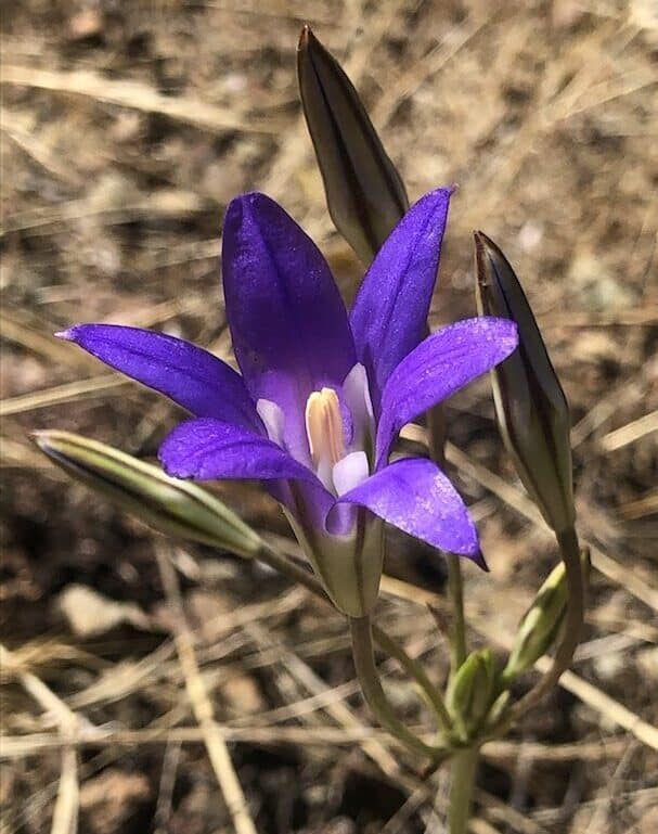
Harvest Brodiaea 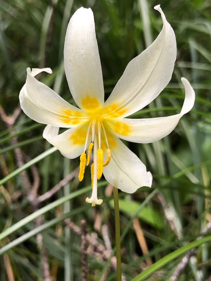
Oregon Fawn Lily 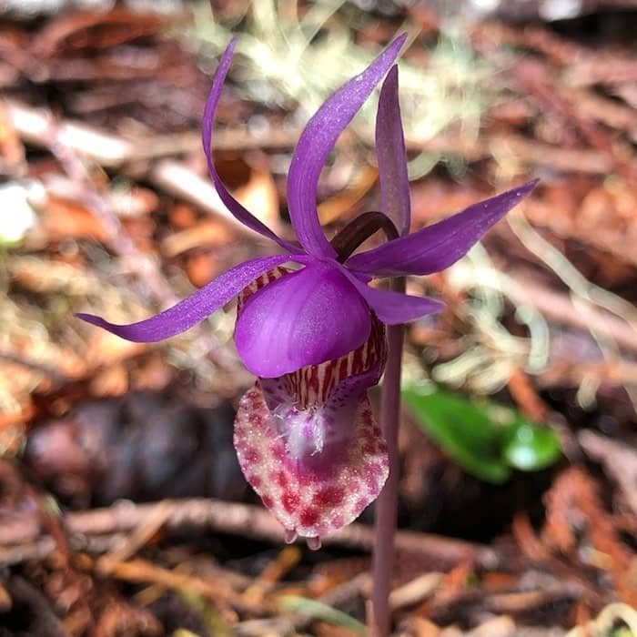
Fairy Slipper Orchid
Up until this point the trail had been in fantastically maintained shape. But the last mile to the valley floor had many sections of winter blowdowns that hadn’t been cleared. Some were up and over, some were under, some were walk arounds and one was a bit of all three. Just part of the early season hiking game and to be expected anywhere forested this time of year.
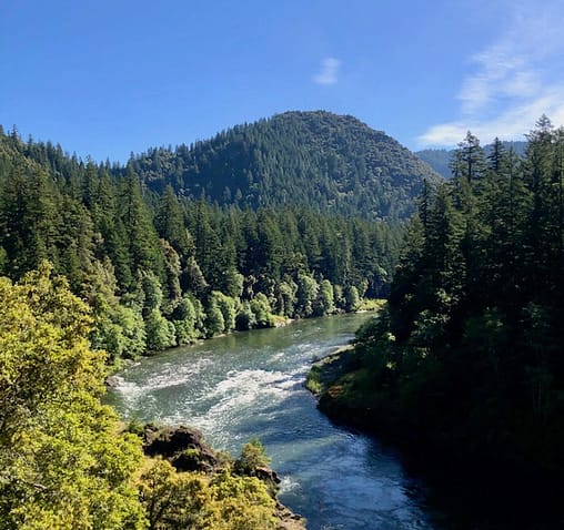
Finally at the Rogue River Trail #1160, our hopes of camping at Tacoma or Tate Creek to shorten our day were dashed. Both areas were crowded or a serious scramble down to the river bank. We rambled on, sore footed until Lower Solitude Bar. There we found a spot with only one other tent, an easy access trail, and an electrified bear fence to cache food.

Oh we haven’t really discussed bears yet? They are absolutely prevalent here, I saw a mother and cubs on my previous trip hiking along the Rogue River. Bear canisters are not required, but highly recommended. I brought an Ursack, but hadn’t practiced with it, so it became a glorified bear hang bag the first two nights. Along the river many camp areas have the electrified bear fences. These are an absolute lifesaver to keep from traipsing through brush and grass trying to find a suitable bear hang tree. In my opinion when hiking in bear country, which most of the west coast is, bear spray is the 11th essential. Like American Express, I don’t leave home without it.
The Fourth Day
Rinsing off the dirt and grime in the Rogue felt otherworldly and helped make for a relaxing evening after our thirteen mile day. With the anticipation of a serene night, we rolled back half the fly and gazed at the stars until we dozed into blissful sleep.
With a need to be in civilization to access internet for school, we rose early and managed a quicker than average exit. No easy feat for me. Despite hiking the Rogue in 2011, I hadn’t verified which stretch we’d be hiking with my memory. Pleasantly surprised our 8.5 mile section was likely the prettiest on the river and a favorite of mine. Clipping along, we were occasionally slowed by washouts yet to be fixed. Most were easy to scamper though, but one was decidedly sketchy with a severe drop off.
Brushy Bar Ranger Station is a verdant oasis on a hot day and a perfect spot for a rest stop. It was early and we hadn’t traveled far at this point so we strolled past. Soon after, we startled the tiniest rattlesnake I’ve ever seen. Unfortunately it was too quick to pose for a pic. We pondered stopping at Paradise Lodge for a soda pop, but they were closed due to the pandemic. Nearby we found some chairs next to a fire pit and relaxed for snack time. I mentally noted that this would be an excellent campsite to fetch icy cold beers from the lodge on a return trip.
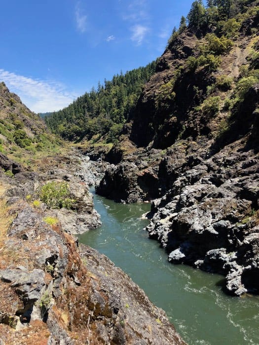
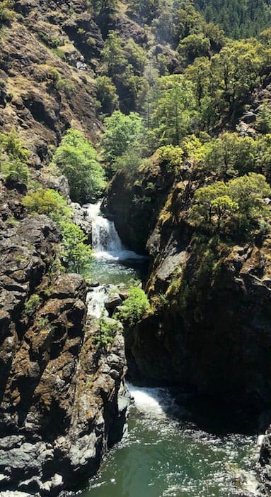
While the whole loop is gorgeous and fit for photo after photo, Inspiration Point is truly a highlight. The trail juts to an overlook, directly across from Stair Creek which flows into a tempting pool before cascading into the Rogue.
Final note, the poison oak was even worse on the Rogue River Trail than the Mule Creek Trail. I’ll leave it at that, as we made it out seemingly unscathed. We still bathed heavily in TECNU at home and carefully cleaned all our gear. Until next hike, happy trails!
- Mileage: 29.2
- Elevation Gain: 3700 feet
- Map: Wild Rogue Wilderness from the Siskiyou Mountain Club or Powers Gold Beach Ranger District from the Forest Service
- Closest town: Glendale, OR and Gold Beach, OR
- Ranger District: Gold Beach (541) 247-3600
- Closest outdoor store: (North) Waldrons Outdoor Sports, Roseburg, OR and (South) REI Medford, OR
If you enjoyed this article please comment, share on social media, or tell a friend!
And if you’d like to know more about me, check out my About and Random Stuff I Dig pages.